

SOILS READER – INFORMATION


The Application
The interpretation of soils results can be difficult. Graphs showing suctions or strains vary considerably and it is possible to mistake anomalous test results or under-draining as being evidence of desiccation.
The Soils Interpreter application seeks to provide guidance for a variety of commonly occurring situations although it can’t replace the skills of an expert geotechnical engineer.
Where the data cannot be interpreted with a high level of confidence the user is recommended to refer to an engineer with appropriate skill levels.


Step 1
Log on to the application and enter your password.
Step 2
Select ‘Register New Claim’ and enter a reference, address and full postcode.
Step 3
Under the headings Bore Hole 1 and Bore Hole 2, tab down the depth columns first, entering the depth at which the samples were retrieved from where you have data. 500mm is a default. If there is only one borehole, complete BH1 column. If you have more than 2, you will have to analyse them as two claims or more. Then move across to the ‘Value’ columns, and again, tab down entering the values relevant to the depth of the sample.
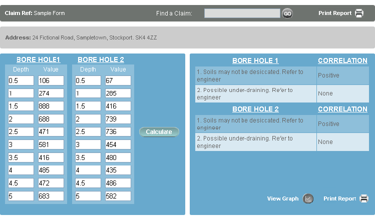
Step 4
Once you have entered the depths and values, press ‘Calculate’ to derive a probability value.
Step 5
Select ‘View Graph’ to plot the results against the template data and establish the match. The correlations have already carried out the statistical matching.
Step 6
On completion, the data is saved against the reference you have allocated and can be re-visited if required and amended.
Notes
The application automatically calculates whether the values you have entered are strains or suctions.
Every graph is compared with a series of templates. The templates cover a wide range of commonly encountered soil conditions including:
(a) desiccation,
(b) desiccation with variable soil mineralogy,
(c) under-draining,
(d) anomalous test result possibly associated with the soil mineralogy and gypsum salts,
(e) values that are too low to be considered as evidence of desiccation,
(f) a possible potential for heave.
Results correlating with (c), (d), and (e) from the above list should be referred as they indicate a soil that is not desiccated.
Two correlations are provided against each borehole. It is unlikely they will be in conflict, but if this does happen, please refer. The first correlation has the closest match to the underlying template.
To search for a claim you have already entered, enter the reference into the ‘Find’ Box and press return.